
A little room to wonder
Rivers & Changing Landscapes
Follow erosion, transport and deposition, then distinguish a visible river feature from a measured process.
How can the same river remove material in one place and leave it somewhere else?
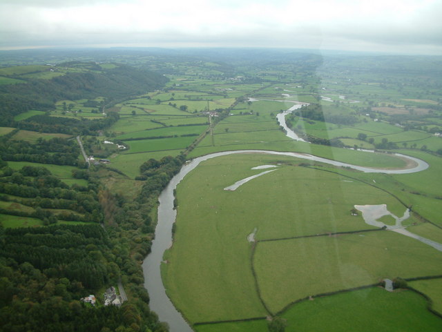
Water moves through a connected area
A river receives water from its catchment: the area that drains towards it and its tributaries. Rainfall can run over the surface, enter the ground or later reach a stream through groundwater. A line drawn as a river therefore belongs to a wider system rather than receiving all its water at its source.
Sediment is material such as sand, silt or rock fragments. Erosion removes material, transport moves it and deposition leaves it in a new location. These processes can occur in different parts of the same river system at the same time.
Read a bend carefully
A meander is a river bend. In a common simplified pattern, faster flow towards the outside of a bend can erode a bank, while slower flow towards the inside can deposit sediment. Over time, the channel’s position may change. Actual flow also depends on depth, bank material, vegetation, obstructions and changing discharge.
An aerial photograph may show bends, exposed sediment or a former channel. It does not measure flow speed or show how quickly a bank is changing. A useful explanation identifies visible evidence and separates it from the processes you propose.
Work through a change estimate
Suppose two fictional, correctly aligned surveys five years apart place a bank 18 metres further east at one measuring point. Dividing 18 by 5 gives an average change of 3.6 metres per year across that interval. It does not mean the bank moved by exactly that amount every year.
Before treating the difference as real, check that both surveys use comparable positions, scales and bank definitions. A different water level can change the visible edge. Measurement uncertainty and a single point also limit what you can say about the whole river.
A landscape records more than one cause
Floods, land use and long-term processes can interact. A field beside a river does not by itself establish why the channel changed. Look for dated observations and alternative explanations. Working from images and records lets you investigate safely without entering water or approaching unstable banks.
Only if you feel like trying
Label a river interpretation
- Use the river photograph and draw a simple outline of one bend.
- Mark one visible feature and one proposed erosion or deposition process in different colours.
- Write what additional dated evidence would help test your explanation.
Optional image activity. Stay with the photograph; do not enter waterways, approach banks or collect sediment.
Look at the sources.
These references informed this introduction. You can check who published them, what evidence they use and whether you would ask another question.
- U.S. Geological SurveyFind-A-Feature: Meander
- U.S. Geological SurveyRivers and the Landscape
- U.S. Geological SurveyRivers Contain Groundwater
Research checked 1 November 2026. External pages have their own content and privacy practices.
Where could this connect?
These are editorial links between subjects. You choose which, if any, to follow.
Geography
River processes link landforms, water and human uses of a place.
Follow this connection
Habitats & Niches
Changing channels and deposited material alter the conditions available to organisms.
Follow this connectionStatistics & Data
An average change over an interval needs context and measurement limits.
Follow this connection