
A little room to wonder
Mapping Microhabitats
A microhabitat is a small part of a larger habitat with its own conditions. A labelled grid can show where observations belong while keeping measurements separate from explanations.
How can neighbouring squares differ without a map proving what caused the difference?
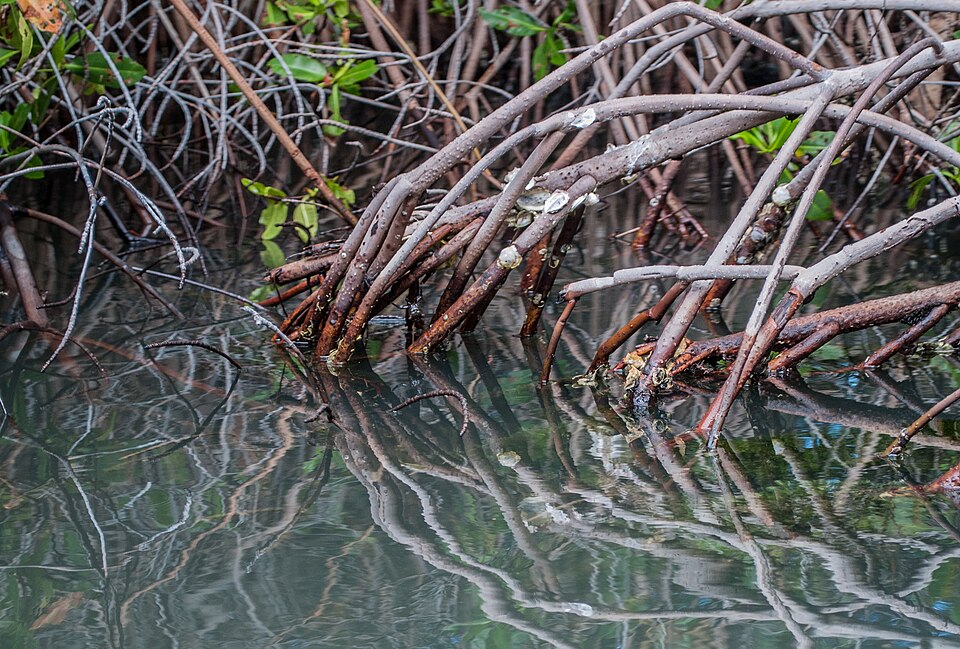
A small place can contain several settings
A shaded space beneath roots and an exposed patch nearby may differ in light, moisture or temperature. These smaller settings are microhabitats within a wider habitat. The boundary depends on the organism and question; a useful map does not require every square to be ecologically identical.
Choose a manageable representation. Give rows letters and columns numbers, show orientation and state what each symbol means. Separate observed features from proposed explanations. A leaf symbol could record visible leaf cover; it should not silently mean cool, damp and suitable for every small animal.
Worked example: four fictional squares
Use a two-by-two paper grid with rows A and B and columns 1 and 2. Invented records are A1: six hours of shade, 17 degrees Celsius, five moss patches; B1: six hours, 18 degrees, four patches; A2: one hour, 22 degrees, two patches; B2: one hour, 23 degrees, one patch. All readings use the same fictional observation period.
The two more-shaded squares average 17.5 degrees and 4.5 moss patches; the other two average 22.5 degrees and 1.5 patches. The records show an association in this small dataset. They do not show that shade alone caused the patch counts: moisture, surface material and earlier conditions were not supplied.
Check the map before trusting the pattern
A location code is useful only when someone else can locate the same square in the representation. Swapping rows or omitting orientation can move a record without changing its number. A legend should also distinguish zero patches from patches not assessed.
A photograph can suggest features worth describing, but hidden surfaces and changing conditions remain unknown. Recording a shaded appearance at one instant is different from measuring shade duration. Do not fill missing measurements by guessing from how green an image looks.
Use the map to refine a question
A sensible next question concerns a specific unmeasured feature, such as whether moisture differs between the two columns. More records under a consistent method could help distinguish explanations. They would still need clear units, timing and an agreed counting rule.
For this enquiry, the supplied grid is the whole task. You may annotate the real mangrove photograph to identify visible spaces, while leaving their occupants and measurements unknown. There is no need to lift objects, enter water or disturb a habitat.
Only if you feel like trying
Make a map with an honest legend
- Draw the two-by-two grid, label all four squares and copy the supplied fictional records into it.
- Create separate symbols for shade duration and moss count. Calculate one comparison between the columns, keeping the units distinct.
- Write one observed association and two unmeasured features that could matter. Mark any information missing from the photograph as unknown.
Optional paper mapping or verbal explanation using invented records and the supplied image. No site visit, collection or disturbance of a habitat is required.
Look at the sources.
These references offer further reading on the ideas here. Check who published them, what they support and what you would ask next.
- Field of Mars Environmental Education Centre, NSW Department of EducationSchoolyard safari learning resource
Research checked 1 November 2026. External pages have their own content and privacy practices.
Where could this connect?
These are editorial links between subjects. You choose which, if any, to follow.
Ecology
Ecology connects organisms with local conditions; a small-area map helps keep those observations tied to particular places.
Follow this connection
Maps & Scale
A map needs a defined representation and legend before positions or distances can be interpreted.
Follow this connectionQuestions & Assumptions
Separating recorded conditions from assumptions makes a follow-up question more precise.
Follow this connection