
Geography · Investigate
Read the shape of a drawn hill
What do contour spacing and height labels tell us about a landscape model?
Read equal-height lines on an invented hill and leave the exact summit unknown.
10–20 minutes, or one small comparison for a first try. More time is optional.
Start here
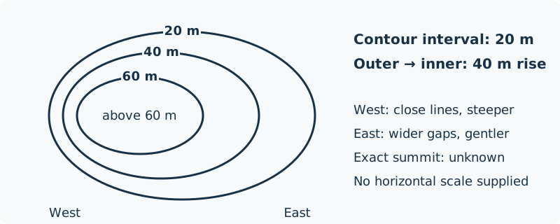
Draw three nested loops and label the outer 20 m, middle 40 m and inner 60 m.
Use your idea or the example below. Talk, write, draw, point or listen first. You can stop after one step.
Try it your way.
Keep equal intervals
Each loop joins points at the same height. In this hill model, height increases inward by 20 m between neighbouring loops.
Compare spacing
Bring the loops close together on the west side and farther apart on the east. Keep the loops nested without crossing.
Read the slope
Both sides rise through the same 20 m intervals. The shorter horizontal gaps on the west indicate a steeper slope than the wider east gaps.
Show uncertainty
Label the inside area above 60 m, with exact summit unknown. The lines alone do not show how or when the hill formed.
One possible version
Original model: one imaginary hill
This schematic is a drawing to interpret, not a survey or a measured landscape.
- The outer, middle and inner loops are 20 m, 40 m and 60 m.
- From the outer to inner loop, the height rises 40 m on either side.
- Contours are closer on the west, so that side is steeper in this model. The exact summit is not labelled.
No horizontal scale is supplied, so an exact gradient cannot be calculated. The drawing does not establish a safe real walking route.
Something to keep?
Which part of my description is supported by contour values and spacing?
You can keep a question, a sketch or a change of mind. A finished product is optional.
This opens an editable starter in your project tools. It asks before replacing open work. Choosing it does not save or share your work automatically.