
Geography · Investigate
Scale an imaginary island map
Which distances can I calculate from a clearly stated scale?
Use a stated scale to calculate distances on a completely imaginary island.
10–20 minutes, or one small comparison for a first try. More time is optional.
Start here
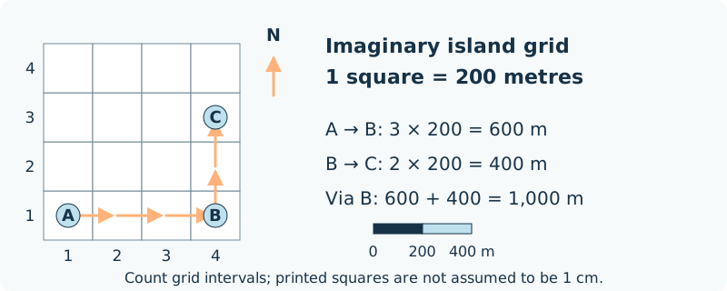
Draw three invented places on a square grid: A (1,1), B (4,1) and C (4,3).
Use your idea or the example below. Talk, write, draw, point or listen first. You can stop after one step.
Try it your way.
State the scale
Each grid square represents 200 metres. On a hand-drawn map with 1 cm squares, that would be 1 cm to 200 m, or 1:20,000.
Count the legs
A to B spans three squares east. B to C spans two squares north. Count the intervals between points, not the number of labelled points.
Convert the route
Three squares represent 600 m; two represent 400 m. The route A–B–C is 1,000 m in this model.
Label what you know
Add a scale bar and north arrow. Count squares on the supplied drawing; resizing a printed illustration does not make each square exactly 1 cm.
One possible version
Original model: an invented island grid
A, B and C are fictional sites. The graphic is schematic and is not an outdoor navigation map.
- A(1,1) to B(4,1): 3 squares × 200 m = 600 m.
- B(4,1) to C(4,3): 2 squares × 200 m = 400 m.
- Via B, the total is 1,000 m. The straight line A–C is a different distance.
Map distance alone does not establish a real route, journey time, access or terrain. The supplied grid must be read by its labels or scale bar, not assumed physical print size.
Something to keep?
Did I count spaces between points or count the points themselves?
You can keep a question, a sketch or a change of mind. A finished product is optional.
This opens an editable starter in your project tools. It asks before replacing open work. Choosing it does not save or share your work automatically.