
Astronomy · Make
A space map with honest scale labels
Which comparisons can one small Solar System drawing show accurately?
Use rounded orbital-distance values to make a labelled scale line, and show which parts are not to scale.
15–25 minutes, or one calculation for a first try. More time is optional.
Start here
Use these rounded average distances from the Sun: Earth 1 AU, Mars 1.5 AU, Jupiter 5.2 AU. Let 1 AU occupy 2 cm on a model line.
Use your idea or the example below. Talk, write, draw, point or listen first. You can stop after one step.
Try it your way.
Convert the values
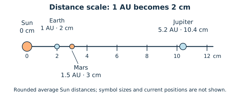
Multiply each supplied AU value by 2: Earth 2 cm, Mars 3 cm and Jupiter 10.4 cm. A labelled sketch is enough if no ruler is available.
Place the markers
Start at a Sun reference mark 0. Put each distance marker the calculated distance along a single line. Treat this as a comparison of distances, not a picture of current planet locations.
Make simplifications visible
Use readable planet symbols and label ‘symbol sizes not to scale’. The supplied averages are rounded; planets travel around orbits rather than staying in this line.
Check one claim
Explain why Jupiter’s marker is farther along than Mars’s. Do not call the 1 cm gap between Earth and Mars markers their actual separation in space.
One possible version
Worked scale: 1 AU becomes 2 cm
This constructed distance line uses rounded NASA average values. It is not an observation of a real alignment.
- Earth: 1 × 2 = 2 cm; Mars: 1.5 × 2 = 3 cm.
- Jupiter: 5.2 × 2 = 10.4 cm from the Sun reference.
- All marks use one distance scale; their symbol sizes and current directions are not represented.
The difference between two average Sun-distance markers is not a general Earth-to-planet distance. This line is not a sky chart or an observing instruction.
Something to keep?
Which distances share a scale, and which visual details are only symbols?
You can keep a question, a sketch or a change of mind. A finished product is optional.
This opens an editable starter in your project tools. It asks before replacing open work. Choosing it does not save or share your work automatically.